
Million Neighborhoods: Mapping Fast-Growing Informal Settlements in Africa
First-of-its-kind interactive map reveals where roads and infrastructure are most needed
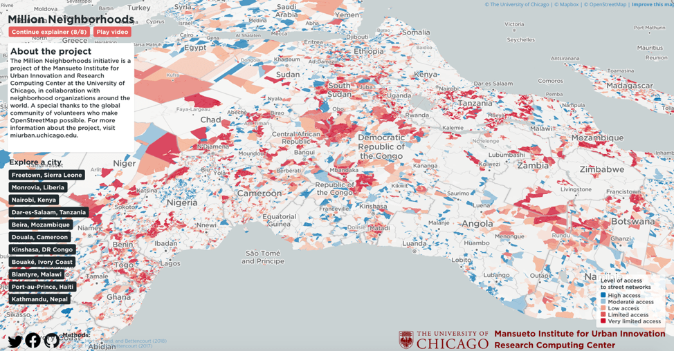
The Million Neighborhoods Map is a groundbreaking visual tool that provides the first comprehensive look at informal settlements across Africa, helping to identify communities most in need of roads, power, water, sanitation and other infrastructure. Updates for Central and South America, India and parts of Europe and Asia will come online in early 2020.
The Million Neighborhoods Map is the first such map of its kind and digitally renders building infrastructure and street networks – or the lack thereof. The goal is to provide municipal leaders and community residents with a tool to help inform and prioritize infrastructure projects in underserviced neighborhoods, including informal urban settlements that are sometimes known as “slums.”
View the map at http://millionneighborhoods.org.
Rapid urbanization in Africa and Asia over the last few decades has led to massive shifts in population and the rise of informal settlements that operate without roads, power and sewer lines. In neighborhoods such as Kibera, Nairobi and West Point, Monrovia, homes are so densely packed that it can be challenging for residents and resources to move through the community, and difficult for urban planners to identify the best areas to build roads, water pipes, power and sewage lines.
The issue is more pressing than ever, as the number of people living in these settlements is expected to triple to three billion in the next 30 years if no large-scale action is taken. Without access to basic infrastructure, residents of informal settlements are more vulnerable to health risks and the impacts of climate change, including flooding, extreme heat and natural disasters.
To create the Million Neighborhoods Map, researches applied algorithms to an open-source GIS database called OpenStreetMap, which is unique because it is available free to anyone and allows volunteers and local residents to contribute data about the location of throughways, buildings and structures – even in informal settlements, which often lack consistent, publicly available data.
“The projected growth of informal settlements, in combination with the challenges of climate change, requires the world’s immediate attention. We hope the Million Neighborhoods Map will create a change in perspective and methods enabling new forms of community-driven urban planning,” said Luis Bettencourt, the Inaugural Director of the Mansueto Institute of Urban Innovation. “Using this map, we can quickly identify the infrastructure deficits of entire cities and pinpoint areas most in need of improvements.”
“This map is a significant step toward locating where critical urban services are needed most,” says Nicholas Marchio, Data Director at the Mansueto Institute for Urban Innovation, whose team of researchers utilized the university’s supercomputer, known as the “Midway,” to calculate the immense amount of information needed to turn terabytes of data into an interactive, easy-to-use website that is accessible on a mobile device.
“We always talk about solutions but first we need to know what the challenges and opportunities are. When a mayor is looking at this map, she can see which neighborhoods across the city require attention, and residents in slums or informal settlements can utilize this data to plan and advocate for their own communities,” said Anni Beukes, Resident Fellow at the Mansueto Institute for Urban Innovation.
The map was launched during the Global Symposium on Sustainable Cities and Neighborhoods, which took place at the University of Chicago on October 23-25, 2019. Officials from UN-Habitat, researchers, technologists, international organizations and community leaders from Africa, Asia, Europe and Latin America gathered to develop a shared agenda toward empowering millions of neighborhoods to tackle issues of human development, infrastructure, and climate resilience.
For the science behind the map, check out:
Brelsford, C., Martin, T., Hand, J., Bettencourt, Luís M. A., Toward cities without slums: Topology and the spatial evolution of neighborhoods (August 29, 2018). Science Advances. Vol. 4, no. 8, eaar4644. https://doi.org/10.1126/sciadv.aar4644
Brelsford, C., Martin, T. Bettencourt, Luís M. A., Optimal reblocking as a practical tool for neighborhood development (June 12, 2017) Sage Journals. https://doi.org/10.1177/2399808317712715
Related news:
Reuters: African Slum Map Exposes True Scale of Urban Poverty
To access the data, fill out our Data Sharing Agreement.
For data and research inquiries, contact:
Cooper Nederhood
Research Engineer (Pre-Doc)
Mansueto Institute for Urban Innovation
cnederhood@uchicago.edu
Satej Soman
Research Engineer (Pre-Doc)
Mansueto Institute for Urban Innovation
satej@uchicago.edu
Nicholas Marchio
Data Director
Mansueto Institute for Urban Innovation
nmarchio@uchicago.edu